


介绍 Tube Map London Underground
● NO INTERNET CONNECTION REQUIRED ●
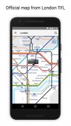
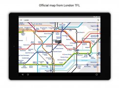
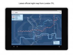
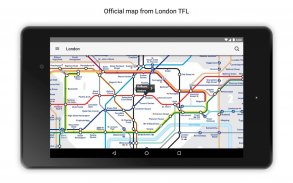
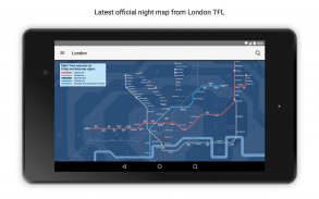
● Latest official TFL (Transport For London) tube map.
● Instant routing while offline
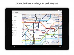
● Simple, fast and easy to use.
● Designed for the first time visitor and experienced commuter.
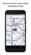
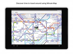
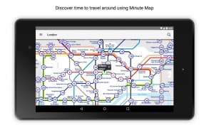
● Unique "Minute Map" feature provides a view of travel times from any location on the map.
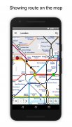
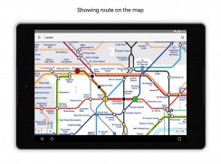
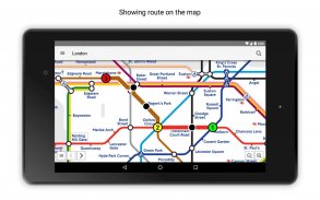
● Planned route animates on the tube map.
●.Switch to online street map (when an internet connection is available).
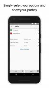
● Services can be turned on or off, routing around problems.
● Works in both landscape and portrait modes.
● Easily locates your nearest London transport stop.
● Places of interest, parks etc are built in to the application.
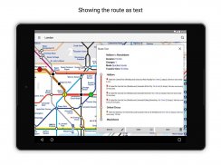
● Offline routing with clear map and text views
● GPS locating
● Station exit information
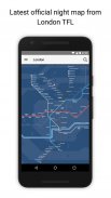
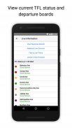
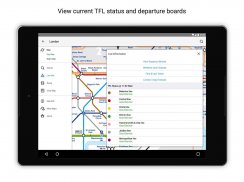
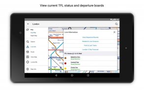
● Live service status and departure board information
● OVERVIEW ● The London Tube Map application is a superb route planner for the London Underground (Tube)system with many unique features. The inbuilt map provides the official TFL map of the city underground services with the ability to switch to an online street map view when an internet connection is available. This way the user can view the online map feature when above ground and the transport map and route planning is still fully functional underground or anywhere there is no internet connection. This provides the best of both worlds, the transport map and route planning anytime, anywhere and online street maps and search when a connection is available.
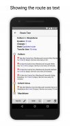
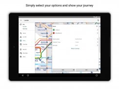
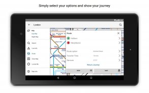
● ROUTING ● Does not require an internet connection and will always be available to display a clear and detailed view of the city transport system, plus list and animate the optimum route for your journey. Provides the fastest route calculations of any mobile routing application (virtually instantaneous) using actual published journey times with the ability to select the quickest route or the route with the least changes.
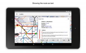
Comprehensive details of your planned route are provided, including changes, directions of travel, number of stops, predicted journey times, etc. Uniquely this application gives you “direction”, “towards” and “service frequency” information (not available on any other offline journey planner) for example “Take the Northern line (Southbound) towards Stockwell for 10 mins (6 stops). Service runs every 7 minutes” which is essential when finding the correct platform and connection. Also given are alternatives for each leg of the journey.
● NO INTERNET CONNECTION REQUIRED ● The tube map and routing do not require an internet connection and therefore you will not be charged data connection fees. This also means the application runs perfectly underground, on an aeroplane, etc. For international visitors to a city who have data roaming turned off this is an ideal solution.
● LIVE INFO ● When an internet connection is available, optional "Live Information" on the current state of the transport services and real time station departure boards can be viewed allowing you to plan your journeys in advance and avoid any potential delays. Unique to this application is the ability to turn off services that are out of action and automatically calculate an alternative route.
● MINUTE MAP ● This unique feature provides a view of travel times from any location on the map. This is helpful for getting a sense of scale and connectivity of the transport system and can provide some interesting results.
●无需互联网连接●
●最新官方TFL(伦敦交通局)地图。
●离线时即时路由
●简单,快速且易于使用。
●首次为访客和经验丰富的通勤者设计。
●独特的“分钟地图”功能可以从地图上的任何位置查看旅行时间。
●计划的路线动画在地图上。
●。切换到在线街道地图(当有互联网连接时)。
●可以打开或关闭服务,绕过问题。
●适用于横向和纵向模式。
●轻松找到离您最近的伦敦交通站点。
●应用程序内置了景点,公园等。
●具有清晰地图和文本视图的离线路由
●GPS定位
●站出口信息
●实时服务状态和离港董事会信息
●概述●伦敦地铁地图应用程序是伦敦地铁(地铁)系统的卓越路线规划器,具有许多独特的功能。内置地图提供城市地下服务的官方TFL地图,能够在互联网连接可用时切换到在线街道地图视图。这样,用户可以在地面上查看在线地图功能,并且运输地图和路线规划在地下或任何没有互联网连接的地方仍然完全正常运行。这提供了两全其美,运输地图和路线规划随时随地和在线街道地图,并在连接可用时进行搜索。
●路线●不需要互联网连接,始终可以显示城市交通系统的清晰详细视图,并列出并为您的旅程制作最佳路线。使用实际发布的行程时间提供任何移动路由应用程序(几乎是即时的)的最快路径计算,并能够选择最快的路线或变化最小的路线。
提供您计划路线的全面详细信息,包括更改,行程方向,站点数量,预计行程时间等。此应用程序独特地为您提供“方向”,“朝向”和“服务频率”信息(不提供任何其他信息)离线旅程计划员)例如“沿北线(南行)向斯托克韦尔方向行驶10分钟(6站)。服务每7分钟运行一次“这对于找到正确的平台和连接至关重要。还给出了旅程中每一段的替代方案。
●无需互联网连接●管道映射和路由不需要互联网连接,因此您不需要收取数据连接费用。这也意味着应用程序可以完美地运行在地下,飞机上等。对于关闭数据漫游的城市的国际访客来说,这是一个理想的解决方案。
●实时信息●当有互联网连接时,可以查看当前运输服务状态和实时电台出发板上的可选“实时信息”,以便您提前计划行程并避免任何潜在的延误。该应用程序的独特之处在于能够关闭不起作用的服务并自动计算替代路线。
●分钟地图●此独特功能可以从地图上的任何位置查看行程时间。这有助于获得运输系统的规模和连通性,并可提供一些有趣的结果。
Tube Map London Underground - 版本2.7.0
(06-05-2021)
Tube Map London Underground - APK信息
APK版本: 2.7.0程序包: com.visualit.tubeLondonCity同类应用
您可能还会喜欢……


